Terragold

Terragold

Bullion Gold

Project Snapshot

Location

Senneterre

Ownership

100%

Drill Program

Validation campaign June 2026

Stage

Permits received and drilling campaign funded

Overview


On February 2, 2026, Bullion completed the acquisition of the Terragold project (38 claims – 2,058 ha), located within the prolific Abitibi Greenstone Belt, 12 km south of the municipality of Senneterre in Abitibi (Québec, Canada). The main gold showing, known since the early 1960s, has been intersected by drilling over a cumulative strike length exceeding 2 kilometres to a depth of approximately 250 meters and has seen very limited exploration activity since 1984. The gold mineralized corridor, associated with a quartz–feldspar porphyry system, remains open in all directions. The validity of the system is supported by a historical 245 kg bulk sample grading 4.84 g/t Au, demonstrating mineralization outcropping at surface.

According to the report described in GM 13299, a trench on gold showing No. 2 exposed a mineralized zone over 8.2 meters. Channel sampling returned the following results: 

Geological Context and Mineralization


Mineralization is linked to a system of felsic dikes of feldspar and quartz porphyry, silicified and crosscut by locally mineralized quartz veins. These dikes are in contact with basalts also injected with mineralized quartz-carbonate veins. The most significant gold grades are found in the most altered and quartz-veined zones. Most drill holes along this structure have intersected significant gold grades over good widths.

Structural Control and Typology

3 fault zones are merging in the project area: the Destor-Porcupine Fault zone (“DPFz”), Uniacke Deformation Corridor (“UDC”) and the Manneville Fault zone (“MFz”). The DPFz and the UDC are two major, deeply rooted Archean-age structural corridors within the prolific Abitibi Greenstone Belt of Ontario and Quebec, famous for their role in localizing world-class orogenic gold deposits. The UDC is often interpreted as the extension or a parallel structure of the DPFz or the closely related MFz.3 fault zones are merging in the project area: the Destor-Porcupine Fault zone (“DPFz”), Uniacke Deformation Corridor (“UDC”) and the Manneville Fault zone (“MFz”). The DPFz and the UDC are two major, deeply rooted Archean-age structural corridors within the prolific Abitibi Greenstone Belt of Ontario and Quebec, famous for their role in localizing world-class orogenic gold deposits. The UDC is often interpreted as the extension or a parallel structure of the DPFz or the closely related MFz.

Work Program

On May 13, 2026, Bullion completed a comprehensive compilation and reinterpretation of historical drilling, geological and structural data culminating in the development of a 3D Leapfrog geological model.

Compilation highlights include: 

On June 9, Bullion mobilized its field team to Terragold. The field program marks the commencement of preparations for Bullion’s upcoming validation drilling campaign, scheduled to begin later this month. Activities will include harvesting vegetation, stripping and exposing the Terragold showing, collecting geological and structural information, locating and surveying historical drill hole collars, finalizing the selection of drill targets, preparing drill pads, and completing other field activities necessary to support drilling operations.

Unlocking a Gold Mineralized Porphyry System


Mobilizing our field team marks the beginning of a new chapter for the Terragold Project. Despite widespread historical gold mineralization and drilling that outlined a mineralized system extending over more than two kilometres, the project has seen very limited exploration activity since 1984. Following more than 40 years of inactivity, Bullion’s recent compilation of historical data and completion of a comprehensive 3D geological model have provided a better understanding of the system and identified several high-priority targets. The upcoming validation drilling program is designed not only to confirm historical high-grade gold intersections, but also to evaluate the full geochemical signature of the mineralized system, including elements associated with the quartz-feldspar porphyry and surrounding alteration zones that were not systematically analyzed during historical exploration programs. We believe Terragold represents a compelling underexplored opportunity within the Abitibi Greenstone Belt and look forward to advancing the project using modern exploration techniques.

Historical Exploration Work (1960-1981) identified 3 significant showings:

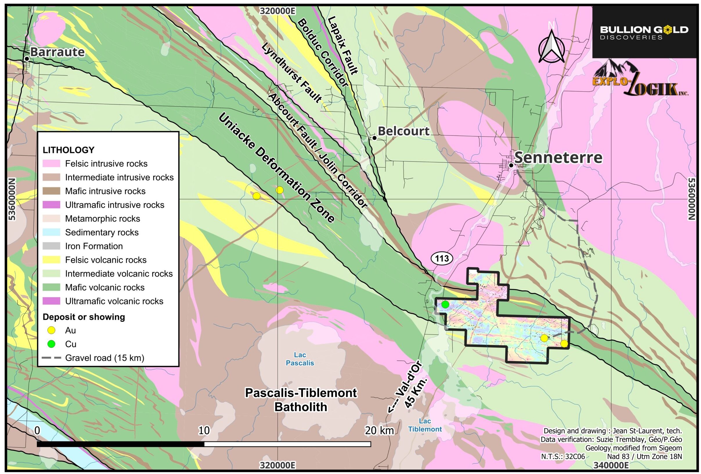
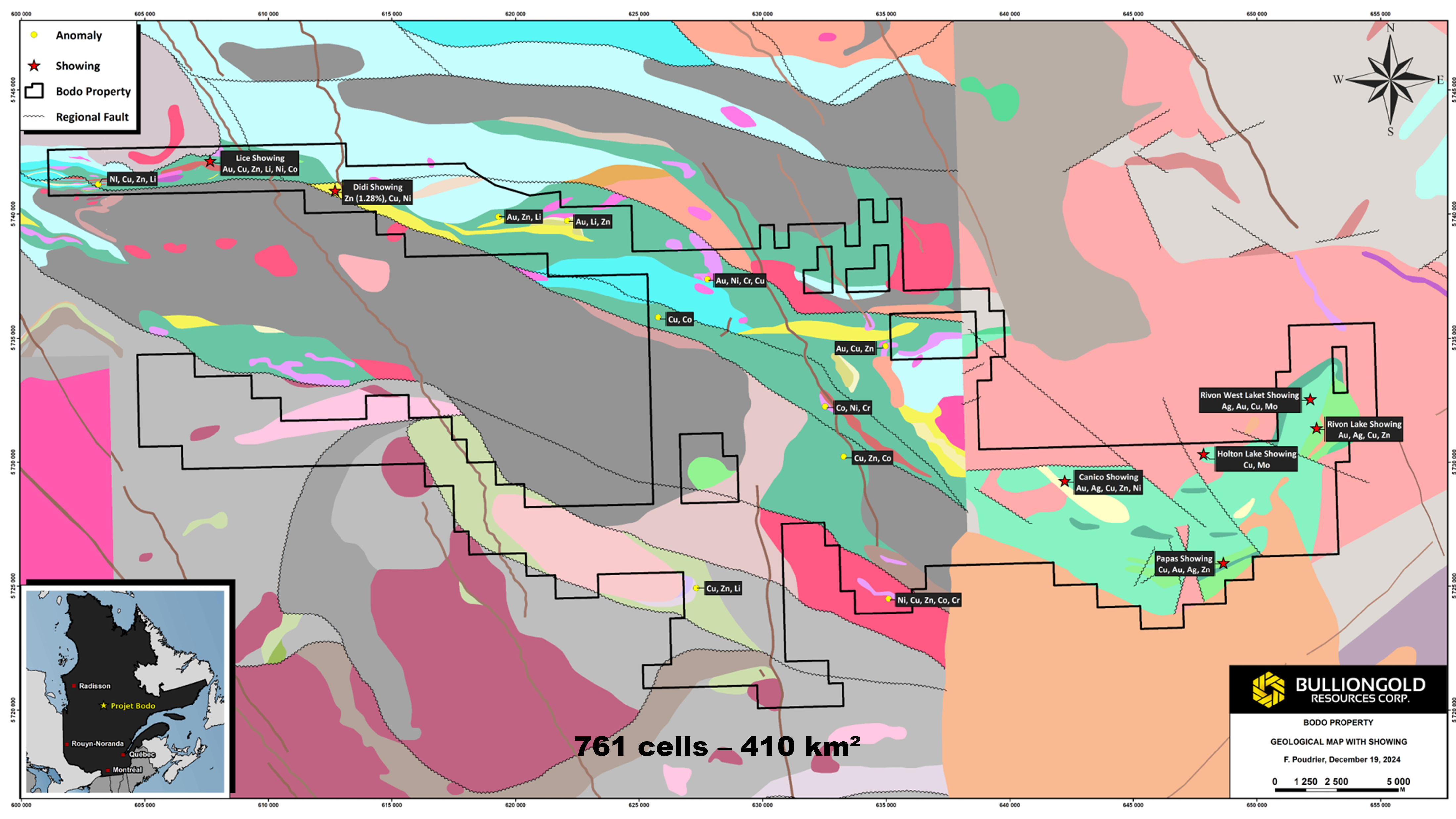
Rivon Showing (Copper-Gold-Silver)
Drilling in the 1960s found a mineralized corridor over 1.4 km
with copper values ranging from 0.50% to 9.9%, gold values
from 1.24 g/t to 5.93 g/t, and silver values from 20 g/t to 238 g/t.

Canico Showing (Copper-Gold-Silver)
Prospecting in the 1960s revealed significant copper, gold, and silver values from both host rock and erratic blocks. Notable results include copper values up to 9.25%, gold up to 2.20 g/t and silver up to 44 g/t.

Papas Showing (Copper-Gold-Zinc)
Drilling by Soquem in 1981 traced a rhyolitic lava zone with anomalous gold, silver, copper and zinc values over 90 meters, indicating potential for a volcanogenic massive sulfide (VMS) deposit.

The Rivon Showing is located in the northeastern part of a broad corridor approximately 3.2 km thick comprising a package of massive and laminated volcanic rocks. The amphibolites represent metamorphic equivalents of basic volcanics. This greenstone assemblage is surrounded by a complex of gneiss and granite.

A few kilometres north of this belt, three narrow discontinuous bands of greenstone are interpreted as the remnants of a single, broader belt. At Holton Lake and a few kilometres south of it are rocks of the Mistassini Group.

East of Holton Lake, a greenstone belt is up to four miles wide and extends westward for a total distance of approximately 80 km.

The presence of copper, zinc, gold, silver and molybdenum is regularly noted in the various exploration works carried out in previous years in these different geological environments.

Seven mineralized outcrops were discovered by Merrill Island Mining in 1963 on the Rivon showing. Three of these were visited by Gilles Duquette, Chibougamau Resident Geologist in 1964 (GM14279). The following description is derived from his report.

“The No. 3 copper showing was stripped and dug in 8 places and copper mineralization was exposed in an amphibolite over a length of over 210 metres. Although these trenches do not line up perfectly, they are confined to a 35-metre-wide band. The mineralization consists largely of quartz and chalcopyrite and pyrite with local concentrations of magnetite. Mineralization on the No. 4 showing consists mainly of lenses of quartz with chalcopyrite, gold, silver and molybdenum. The blasting and stripping done at the time exposed an area approximately 40 metres long and 8 metres wide (Graph 4),” underlines the resident geologist at the time.

Two series of short holes (Series A and Series B) undertaken by Merrill Island Mining in 1963 on the Rivon showing demonstrated the significant presence of copper, gold and silver in the majority of the holes. The holes of Series A drilled in a low intensity magnetic anomaly and located approximately 500 meters to the west of Series B cannot in any case have reached the polymetallic horizon of Group B, which is associated with a high intensity magnetic anomaly. The anomalous presence of copper, gold and silver is noted in both zones over thicknesses varying from 5 to 12 meters. This suggests that there could be several parallel mineralized zones in this sector of the Rivon showing. The two series of holes were drilled from north to south over a distance of approximately 450 meters for Horizon A and 1.3 km for Horizon B. Both horizons remain open in all directions.

Project Gallery


SIGN UP FOR UPDATES

Subscribe for the latest updates from Bullion Gold Discoveries Corp